TROPOSPHERIC DUCTING IN AUSTRALIAS SOUTH - March 2010
This information is written to assist people in looking for Tropospheric propagation in the south of Australia. Mainly directed at those in VK3, VK5, VK6 & VK2 east of the great dividing range, also northern VK7 & at times VK1. The information may assist others as a general guide also.
GENERAL RULE 1 : HIGH PRESSURE CELLS. In the South East area, you need to have had a front pass u by and the leading edge of a new High Pressure Weather system in your area.
GENERAL RULE 2 : HUMIDITY. There needs to be a good deal of moisture in the air. Generally levels over 50% is good. Hence being on the coast or close to it works a lot better than being inland.
GENERAL RULE 3 : WINDS. Need to be drawn off the southern ocean in a SW flow (for stations in the SE). Will generally calm down over night n be still in the morning. This also draws the humidity up.
It is a VERY good idea to have a high quality weather station at your location to measure the weather parameters. To be able to monitor the Barometric pressure, the relative humidity and the wind is extremely handy if you want to grasp what is happening better.
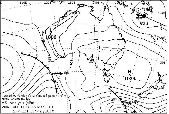
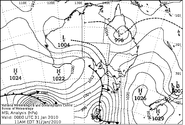
This is what happens and what I look at. I have attached below a BoM MSLP weather map, this is the current one as at the time I am writing this information.
So, what we can gather from this map is, that we are in the tail end of a high pressure system that has passed us by. At this point in time I would expect rather depressed tropospheric ducting conditions. Reasons being, the air from the system is being pulled down from the inland, making it very dry air and warmer. Winds come down from the NE, or generally in a northerly direction.
Around this time and on approach of the incoming cold front, signals will generally be up a bit in a north south direction, for example between here and southern VK3 and Adelaide to Mt Gambier. Paths from Adelaide to here will usually be much depressed.
The map below is the map from the new VK2 70cm distance record (VK2KRR-VK6WG).
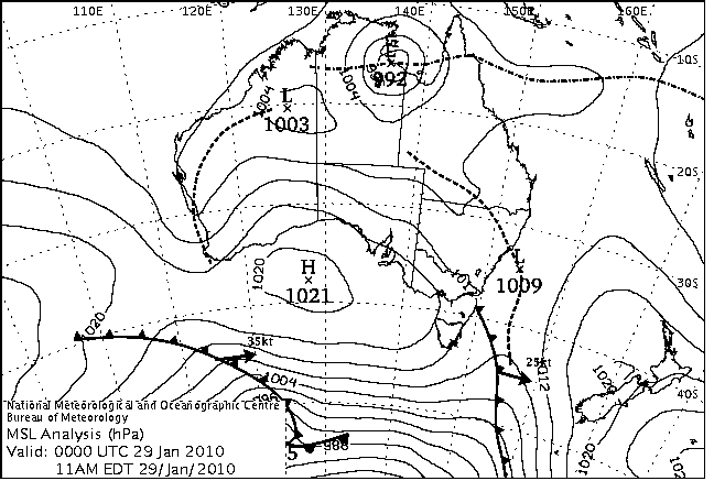
It is important to note in this map that, at my location (and VK3) the cold front shown has passed and I would be getting a SW wind coming up from the ocean. With a weather station you can tell when the front has passed by watching the barometric pressure, it will start to rise. Also the wind will swing around and start to come from the SW. The humidity should also rise. You are now in the new high pressure system. You now have access to what ever conditions the new high pressure cell contains.
Also in this map, the contacts were made to VK6 from VK2, also VK5 and VK3. To get contacts to VK6, it is very important for the LOW pressure trough to be positioned as far west of the VK6 coast as possible (the dotted line near Perth). While it is off the coast, the winds are still coming from the NE and means the VK6 stations are still in the area of the high system that's in the Bight. If the Low press trough moves inland, as it often does, it can cut out stations near to it and to the west of it due to the unstable air near the trough and also if your on the west side it means your in the trailing high cell that's out in the Indian ocean, not the one in the Bight.
So you can see in the map above, that for a short period of time, paths are available from east to west.
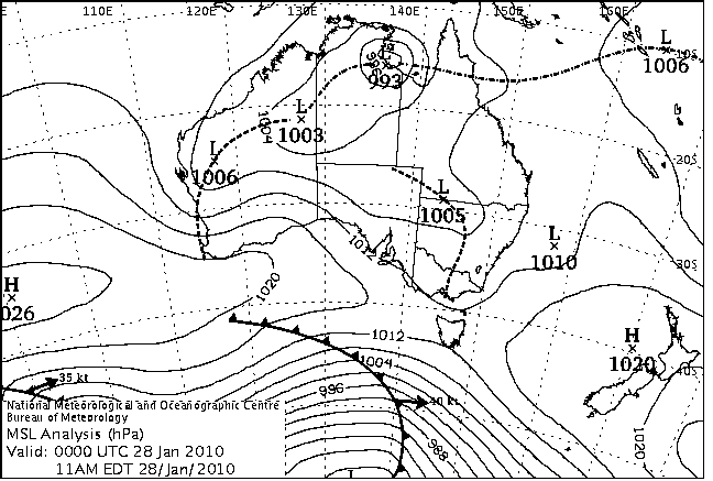
This is a view of the MSLP maps before and after the contacts were made. In the first map below, you can see there was a low trough down VK2 and VK3. There is also a low trough off the coast in VK6. You can see a cold front sweeping south of the Bight. This cold front will move through and push the low trough out of the VK2/3 area, behind it will be a new area of high pressure.
In the map below, which is the VK2 record map, you can see as explained, that the cold front has moved through and also pushed the low pressure trough out off the NSW coast. This leaves the path in good condition for VK2/3 to VK6 contacts, along with the low trough being off the coast of Perth.
In the map below, you can see that the cold front that swept VK3 is moving toward NZ (ZL). The high cell that contained the conditions for VK2 to VK6 is moving across also. The cold front and low trough in SW VK6 have combined and moving east. This will cut out the VK6 end. Behind the front moving across the Bight is a new High cell, and new opportunities to investigate. Conditions across the south would be much deteriorated at this stage when again hot dry air is being dragged down from inland with North winds.
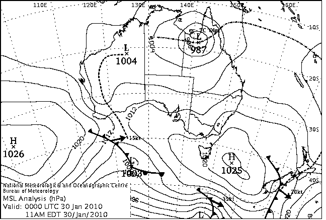
In the map below, conditions are pretty much totally ruined for long DX. Trough and front sweeping into VK3. At times there can be good conditions before the front in the hotter air and moisture around the trough. Leading to north south contacts in VK3 and 5 & 2. In VK6 they would be experiencing the new air from the new High cell, stations in Adelaide and Mt Gambier would almost be ready to try back across to VK6 again. VK3 and 2 will have to wait till the front moves across their area before the have any chance.
And that is really about it. So really, each new High pressure cell has new opportunities to investigate and this is what you should be watching out for. With each front that passes and new High cells approach, its a good idea in the mornings and evenings to have look out for beacons and see whats happening with the signals in your area to see what is propagating your way. A lot of the time its going to be fairly disappointing, but if your keen on Tropo, you still really need to check, because sometimes you will be taken by surprise, and you just never know what may be in that new weather system that's arrived in your area.
Just of further note. Sometimes in the south east, we can be held in a situation where the air goes 'stale'. We can have sunny skies for days and days. This is usually caused by low pressure troughs just hanging around and no strong fronts to push them away and bring in new air. So while the weather just sits there like that, nothing is going to change and nothing different will happen day by day. Bit of a pain, but not much you can do about it but wait for a change.
Hope some of this info helps.
Regards
Leigh Rainbird
VK2KRR
16.03.10